Where is the source of the Urals. The Ural River on the map of Russia. Where it flows, where it is, source, characteristics. Mode, nature of the flow
The Urals is a distant land rich in precious stones, useful ore, wise people and original tales. It united many nationalities, stretching from north to south for more than 2.5 thousand kilometers. High sheer cliffs, dense forests, fertile fields and clear lakes and rivers of the Urals were sung by poets, artists, romantic bards.
The full-flowing Ural River flows down from the southern end of the ridge.
Name history
The river with the name Ural appeared on the map of Russia only in 1775 by decree of Catherine the Great. Prior to that, in all languages the river was called Yaik. The word came to the Turkic and Bashkir languages from the ancient Iranian daiks. Under this name, the river is mentioned in the 2nd century BC in the work of Ptolemy.
In some ancient sources there are other names: Daih, Likos, Yagak, Ulusu, Dzhaikh, Zapolnaya river.
In translation, "yaik" means "overflowing" or "wide". The floodplain of the river in some places is up to 10 kilometers.
In the Russian chronicle, this name is first found in 1140.
On European medieval maps, the river was signed as Rhymnicus or Rhymnus.
In 1773, the Pugachev uprising broke out in the Urals. Local peasants, Bashkirs, Kazakhs and Yaik Cossacks participated - the Cossack army, which settled on the banks of the Yaik in the 16th century. They founded the Yaitsky town and intermarried with local foreigners. The Cossacks served even Mikhail Fedorovich Romanov, the first of the dynasty. But they refused to submit to the new orders of Catherine II. Having severely suppressed the uprising, the empress decided to forever consign to oblivion the very name of the area and ordered to name the Yaitsky town of Uralsky in accordance with the name of the mountain range, the Cossacks - Ural, Yaik - the Ural River. Kazakhs and Bashkirs continue to use the old name.
Location on the map
The Ural flows through the lands of several regions of Russia:
- Bashkortostan;
- Chelyabinsk region:
- Orenburg region.
Then it crosses the border of the Republic of Kazakhstan.
The nature of the current varies greatly depending on the surrounding landscape, season, weather.
Source and tributaries
The source of the Ural River is five springs ten kilometers west of the village of Voznesenka in the Republic of Bashkortostan. Behind the mountain range in the west lies the valley of the Ai River, which gives rise to the Urals. It all starts with a small spring in the Uraltau mountains at an offset of 637 m above sea level on the slope of the Round Hill. It is believed that this point lies on the line dividing Eurasia into Europe and Asia. Members of the expedition that visited here in 1973 installed a commemorative plaque. On it, the Ural River is schematically depicted on the map, the largest cities are marked with circles. Later, a small metal bridge was thrown over the stream, symbolizing the unification of the western and eastern worlds.
At the foot of the Nazhimtau and Uytash mountains, several more springs join the stream. These small springs are not the only source of water for the river. The Ural collects water from eight dozen tributaries. The most important of them are Sakmara and Ilek.
Sakmara starts in Bashkiria. She brings the Urals the most a large number of water. This is a stormy mountain river, on the banks of which people live with pleasure.
Ilek almost twice as long as Sakmara, but carries 2.5 times less water. It flows from Kazakhstan. The Ilek valley can compete in width with the valley of the Urals itself.
Two more significant tributaries - Tanalyk and Sunduk - do not flow into the Urals, but into the Iriklinskoye reservoir.
Other major tributaries:
- left: Or, Bolshoi Kumak, Gumbeika, Urta-Burtya, Bolshaya Karaganka, Zingeyka;
- right: Chagan, Big Kizil, Irtek, Small Kizil, Guberlya.
Although the area of the basin on the left side is more spacious, there are more right tributaries. These are fast mountain rivers. On the left, quiet flat streams adjoin the Urals.
river mouth
The Caspian Sea, where the great Ural River flows, is located on the division between Asia and Europe. It is considered a sea only because of its large size. The Caspian takes the first place in the list of endorheic lakes of the world.
The mouth formed a delta at around 27 m below sea level. This is characteristic of slow-flowing rivers with internal flow. The total fall of the river is 664 m. Due to the irregular weak supply, the delta branches gradually become shallow and disappear. In the middle of the 18th century there were nineteen of them. A hundred years later, the number was reduced to nine, and later to three:
- drag and drop;
- Zolotinsky;
- Yaitsky.
The first is separated upstream of the other two. Each sleeve branches into two ducts. The Bukharka channel, which runs to the sea between the Golden and Peretask, is also referred to the Zolotinsky.
river basin
The area of the Ural River basin is 231,000 square kilometers and ranks sixth among Russian rivers. The territory of the valley is unevenly distributed - two thirds fall on the left bank. In the upper and middle reaches, the drainage space covers the lands of Russia and Kazakhstan. The main part of the valley is concentrated in the Orenburg region. The river collects runoff from the surrounding land for 1164 km. Here the Ural meets the most rivers.
The river bed is winding, often changing position, leaving lakes, oxbow lakes and settlements away from the main stream. Every year during floods they are refilled with water.
The southern section passes through arid regions, there are few tributaries here. If you look at the map, you can compare the outlines of the river and valley with a tree. The crown is spreading, many curved branches. This section of the scientific language is called furking, i.e. branched. The trunk at the base is wide and almost bare.
Mode, nature of the flow

The entire territory where the Ural River currently flows lies in the continental climate zone. In summer there is a strong heat, in winter - frosts. The ice rises in November and stays until March. The river fully justifies its first name. The water level depends on the amount of snow by 70-80%. Shallow during the boundary period, during the melting of snow, it draws up to ten times more water. With a width of the main channel of 50-170 m in high water, the width of the mouth of the Ural River can reach up to 36 km. For this short period, the main runoff for the year is passed. The depth is 3-5m. Length - 2428 km. It is the third in Europe after the Volga and the Danube.
At the beginning of the path, the flow moves from north to south. In the upper reaches it is a fast mountain stream, about one and a half meters deep. The bottom here is rocky. Further, in the middle part, it is sandy-pebbly, silted off the coast. At the mouth, alluvium accumulates from sandstones eroded upstream. After passing through the Yaitskoye swamp, the river expands to five kilometers and loses its violent temper. Between Verkhne-Uralsk and Magnitogorsk, the nature of the current is flat. Before Orsk, the slope of the channel averages 0.9 m per kilometer. Further it becomes even more gentle.
Having rounded Orsk, the Urals are heading northwest. Below, on the territory of the Guberlinsky mountains, rapids and rifts reappear. This stretch of 45 km attracts a large number of visitors, especially beautiful views. Connecting near Orenburg with Sakmara, the river acquires calmness and slowness. Lazily follows the southwest along the border of Kazakhstan and Russia, losing about 0.3 meters of height per kilometer of length.
On the border with Kazakhstan, near the city of Uralsk, the channel returns to the south and winding, or meandering, reaches the Caspian Sea. Here the river becomes full-flowing and wide - up to 200 m. The distance from the surface of the water to the bottom in places reaches 6 m, and in the reaches up to 12 m. The banks are mostly low, although in places where they coincide with the edge of the river valley they reach 20 m.
The complex nature of the river caused the death of the hero of the civil war, Chapaev. According to one version, he drowned while swimming across a turbulent stream. The village of Lbischensk, where the tragic event took place, is located on the territory of Kazakhstan. Since the forties of the XX century, it has been called Chapaev.
Flora and fauna of the Ural River
During the boundary period, the floodplain of the river is covered with frequent blackberry and blackthorn bushes, forests and water meadows. In some lakes there is a rare relic plant - chilim, or water chestnut, listed in the Red Book.
Going on a “silent hunt” here is a real pleasure. Red-headed boletus, crunchy milk mushrooms and other edible mushrooms grow well on soil fertilized with silt.
As you move along the coast, nature and the animals that live here change. Reindeer are found in the cold climate of the upper reaches of the Urals. In the conditions of the taiga, predatory fur-bearing animals have taken root: sables and ermines. Bears, lynxes, wolves, foxes feel great. Their game runs right there: deer, roe deer, elk. Beavers, otters and muskrats settle closer to the water. Small rodents, snakes, lizards live in the southern steppes.
About 240 species of birds nest in large reservoirs, including gulls and terns.
The main pride of the Ural River is fish. More than four dozen species live and spawn here. The most popular are roach, pike, lamprey, crucian carp, ide, carp, perch, trout, ruff, asp, sterlet, burbot and other permanent inhabitants. Stellate sturgeon, beluga and sturgeon come to spawn. Periodically you can meet pike perch, vobla, bream.
reservoirs

Iriklinskoe reservoir
The water of the Urals is used for irrigation and electricity generation. The unstable regime of the river forced people to take care of moisture reserves. To provide water to large cities along the stream, three reservoirs were created in the Urals during the Soviet period:
- Verkhneuralskoe;
- Magnitogorsk;
- Iriklinskoe;
The first two reservoirs were created near the city of Magnitogorsk.
Verkhneuralskoe appeared in the sixties specifically to provide the Magnitogorsk Iron and Steel Works. It is located between Verkhneuralsk and Magnitogorsk. Its dimensions are 23 by 3 km, the depth reaches 10 m. Therefore, among the people, the reservoir was named the Upper Ural Sea. It was supposed to replace the old Magnitogorsk reservoir. Now it is a popular holiday destination. On its shores there are tourist centers and campsites, a yacht club has been formed.
Earlier, in the thirties, when the metal processing plant was just being built, Zavodskoy Pond (Magnitogorsk Reservoir) was used for its needs. This is an artificial reservoir of the channel type. It is located within the city. The area of the mirror is 33 square kilometers with a length of 24 km and an average depth of 5.5 m. technological processes. The sewage treatment plant was launched only in 1954. The modern Zavodskoy Pond is quite clean. Locals come here for picnics. Rowing and swimming competitions are regularly held on the water.
The Iriklinskoe reservoir is the largest in the Southern Urals. Its area is 260 square kilometers, depth - up to 40 m, volume - 2160 million cubic meters, length - 415 km. It has been filled for eight years since 1949. Several settlements were flooded, the oldest of which was Tanalyk, founded in 1743. In the middle of the 20th century, a hydroelectric power station worked on the reservoir until it was replaced by a state district power station in the city of Energetik. Now this artificial sea has been chosen by tourists, fishermen and fisheries. Of the many islands, Love Island, Ust-Burlinsky, Koshar and Hanging Stone are distinguished. Water is taken from it for the Orsk-Khalilovsky industrial complex and irrigation of agricultural lands. Cities from Gai to Orenburg feed on water.
In addition to man-made, the Ural valley is decorated with many natural lakes.
The border between Asia and Europe?

The channel of the Ural hand really runs along the geographical border of Europe and Asia. But only in the upper and middle course, located on the territory of Russia. The monument to the border was erected in Orenburg. It demonstrates that one side of the Urals is in Europe, and the other is in Asia.
In fact, the dividing line runs in the Chelyabinsk region. Directly on it are Magnitogorsk and Verkhneuralsk. The latter also has a memorial sign.
In Kazakhstan, the Ural is a completely European river. The channel here deviates to the west from the border of the continents, which runs from Orsk to the high mountain range of Mugodzhary. To the south of it stretches a sandy desert belonging to Central Asia.
River navigability
In the past, the Urals were quite deep. There was a permanent water route between Uralsk and Orenburg. But gradually the river became shallow. Now the Yaitsky and the Golden arms of the delta are navigable. From the sea, you can freely walk to the port of Atyrau. These are mainly fishing and cargo ships. They transport commercial fish and fruits (melons and watermelons). A significant part of the income of the city and the country comes from the extraction and transportation of oil, which is produced near Atyrau.
Monuments of nature in the Urals
The area in which the Ural River is located is diverse and full of natural wonders.
Picturesque places attract tourists and fishermen to Bashkortostan, where near the village of Yangelsky you can wander along the rocky shore along the White Stone cliff. Inside, the remains of fossils are frozen in pieces of antiquity. Rare lichens and plants grow here, animals listed in the Red Book live.
The mountain, with the wonderful name Izvoz, used to serve as a resting place for peasants who transported ore to Beloretsk. Then there was a chapel at the top, destroyed during the Civil War. An obelisk was erected in memory of the dead. Later, pine trees were planted on the slopes, and paths for tourists were laid. Now this area is protected as a natural monument.
Many tourists tend to go through the Orsky Gate, past the Nikolsky cut, look into the Iriklinskoye Gorge, admire the Cross Mountain, bypass the Noisy Roll, go fishing in the backwater near Mayachnaya Mountain.
Near Chesnokovka stands Maiden Mountain - Kyzlar-Tau. Local girls used to come to the dam at its base. They danced, played, swam. Young guys came here to spy on them. But they tried not to catch the eye of the lively Cossacks. In addition to the legend of brave horsemen who watched the games of girls, this place is known for sandstone of an unusual red color.
The Treasure Coast is located on the right bank of the Urals between Orenburg and Ilek. It is rich not in precious stones, but in a unique natural landscape created by water, wind and solid deposits of chalk, limestone, white clay, marl and iron sandstones.
The main cities on the Ural River

From time immemorial, people have settled on the banks of the Urals. With the development of industry, large cities grew from small settlements. The most notable of them:
- Verkhneuralsk, which became early XVIII centuries, a stronghold of researchers of the Yaik River and a port for supplying the builders of the future city of Orenburg;
- Magnitogorsk, which grew up around a metallurgical plant;
- Orsk, near which Orsk jasper is mined near Mount Colonel, known for its unusual and varied color;
- Novotroitsk, which grew up near the Khalilovsky mineral deposit - brown iron ore, and a processing plant;
- Orenburg, an outpost on the border with Asia, which has turned into a major trading center;
- Uralsk, the former Yaitsky town - the cradle of the Cossack uprising of 1773, the stronghold of Pugachev until 1775;
- Atyrau is a significant port and oil capital of Kazakhstan.
The history of each of them is full of unexpected turns and curious facts.
Fishing and rafting
The rapids of the Ural River attract rafting enthusiasts. For the conquerors of the water element, bases were built on the banks. The route along the gorge in the Guberlinskie mountains is popular for rafting. Tours are arranged for cautious tourists. For kayaks, a route with a length of 876 km and a duration of 28 days has been developed.
The beauty of the Ural shores cannot compete with the popular routes on the amazing Ai or Chusovaya rivers, a tributary of the Kama, famous for its stone fighters. But there are no less people who want to spend their holidays here.
Those who are interested in history are happy to visit abandoned fishing villages, from which the channel moved away many years ago. As more land was devoted to agriculture, the steppes were developed, forests were cut down, the flow of water decreased and the flow increased. All this led to the shallowing of the river. When it became obvious that the water was getting smaller every year, various programs began to be applied to preserve the reservoir. However, it is too early to talk about the results.
In the seventies of the XX century, black caviar was mined here. Recently, sturgeons have decreased by a third. But despite the difficult environmental situation, the waters of the Urals, for fishermen, are a real treasure trove. The reservoirs support a population of different fish species. Ordinary fishing from a boat and from the shore, diving and spearfishing are developing.
The Ural River, like the Ural Mountains that gave birth to it, united ancient history, scientific achievements and picturesque nature. It became a home for people and animals living in the vicinity. It does not divide Eurasia; on the contrary, it unites Asia and Europe.
The length of the Ural River is 2428 km. This is the third longest river in Europe, second only to the Volga and Danube. It flows into the Caspian Sea.
The Ural is one of the few rivers that has changed its name in our time. Before the uprising of Emelyan Pugachev, this river was called Yaik. In order to erase all memory of what happened, Empress Catherine II in 1775 ordered to rename the river, from which the bloody rebellion began. So Yaik turned into the Urals. “For the complete oblivion of the unfortunate incident that followed on Yaik” - this is how the reasons for changing the name in the decree were justified. Let me remind you that the Yaik Cossacks took an active part in that uprising.
The Ural River near Novobayramgulovo in Bashkiria
The toponym Yaik meant in Turkic “overflowing, flooding”, and the modern name is given for the region. On the map of Ptolemy in the 2nd century AD, the river was marked under the name Daiks. In Russian written sources (in chronicles) it was first mentioned as Yaik in 1140. The modern name of the river in the Bashkir language is Yaiyk, in Kazakh it is Zhaiyk.

The Ural River begins in the Uchalinsky district of the Republic of Bashkortostan on the eastern slope of the Ural Range. Three main sources flow down from the lintel between the Nazhim (816 m) and Kruglaya Sopka (1016 m) mountains. Near one of the springs on the slope of Mount Nazhim there is a cast-iron plate with the text: “The Ural River begins here.” Flowing into a swampy valley, the sources form a common stream.
It is interesting that in 1717 the first gold expedition worked on the Ural River (then Yaik), headed by Colonel Dmitry Ugrimov, later the Tyumen governor.

The Ural River near its beginning. View from Mount Kalkan, Republic of Bashkortostan
The river flows through the territory of the Republic of Bashkortostan, the Chelyabinsk and Orenburg regions and Kazakhstan. Most of it falls on the Orenburg region (1164 km), where the river flows from east to west. Despite the name associated with the Ural Mountains, the river already acquires a flat character in its upper reaches. The width of the valley reaches 2–2.5 km. 7-8 km below the city of Orsk, the valley narrows, forming the so-called Orsk Gate. There are beautiful rocks along the coast. The Ural River crosses the jasper belt, thanks to which in some places on the banks you can collect a collection of jasper.
The area of the river basin is 231,000 km2. The average water discharge at the mouth is 400 m 3 /s. The average annual runoff is 12.6 km3. The food is snow, more than 80% of the annual runoff occurs in the spring. In high water, the river overflows its banks, overflowing in places for 5-8 km, in the lower reaches - up to 20-25 km. The sharp uneven runoff is leveled off by the Magnitogorsk and Iriklinsk reservoirs.

Embankment of the pond on the Ural River in Magnitogorsk with graffiti
The river often changes its course, washing away the banks and forming oxbow lakes. Some settlements in the past were based on the banks of the river, and over time turned out to be away from it, or even completely washed away by the advancing river. The bottom in the upper reaches is rocky, in the middle and lower reaches it is predominantly clayey and sandy.
The most significant tributaries (on the territory of Russia): right - Mindyak, Small Kizil, Yangelka, Bolshoy Kizil, Hudolaz (Tuyalyas), Bolshaya Urtazymka, Tanalyk, Guberlya, Sakmara; left - Gumbeika, Zingeyka, Big Karaganka, Sununduk, Big Kumak, Or, Ilek.

The largest settlements: the cities of Verkhneuralsk, Magnitogorsk (Chelyabinsk region), Orsk, Novotroitsk, Orenburg (Orenburg region), Uralsk, Atyrau (Kazakhstan).

Shipping is not developed. Although in the past there was water transport from Orenburg to Uralsk. Despite its great length, the river is shallow. By the way, we had one of the brightest impressions from visiting the city of Orenburg right on the bank of the Ural River. I was surprised that the townspeople actively bathe in the Urals right in the center of the city. A rarity for large cities due to severe pollution of rivers. Despite the fact that, approaching Orenburg, the river already covers a very long distance, in summer it is not wide and shallow here. In some places you can go from one coast to another.

The Ural river in the city of Orenburg
According to the evidence, the river used to be much deeper. Shallowing is associated with the construction of reservoirs, the plowing of steppes and the destruction of forest belts.
M.V. Malakhov wrote in the 19th century:
“The Ural River, with its course, serves as a continuation of the Ural Mountains, as the border between Europe and Asia. This is the ancient Yaik, a name that was forbidden and, as it were, cursed for the fame that the uprising of the Cossacks led by Pugachev had previously received. This was the reason why the ancient name was forgotten. In terms of the length of the course, the Ural is one of the largest rivers in Europe, but not in terms of the abundance of water. Born on the Asian side of the mountains in the Kalganau gorge, the Ural receives its first tributaries from gorges protected from rain winds. The average precipitation in the form of rain and snow in the upper basin of the Urals probably does not exceed 40 cm, decreasing gradually from north to south; upon entering the plain, the river cuts through countries where the annual rainfall does not reach 25 cm and most of the water evaporates. Its bed, formed by clay sediments, is almost everywhere more than 100 meters wide, sometimes reaching 175 meters.

In the past, the river was famous for its fish wealth, especially sturgeon. P.S. Pallas in the 18th century wrote in his book about the fish riches of the river:
“In the Yaik River, sturgeon, beluga, spikes (a special genus of sturgeon, which are so named for their smoothness and sharp nose), stellate sturgeon, sterlet, catfish, carp and white fish are usually found, and from small and simple fish there are pikes, pike perches, bershiks , breams, chubs, sabrefish and a lot of small fish ... All these fish go in herds, and especially stellate sturgeon is in Yaik such an inexpressible multitude that under Guryev you can clearly see the darkness of these in the water. All the Cossacks assure that before this, at the Yaik town, from the strong pressure of the fish, breaches were made in the uchug or slaughter carried across the river, and they were forced to put cannons on the shore to drive the fish away with firing.
Now this fish is scarce, it is found only in the lower reaches. Although even now you can catch on the ear. Perch, bream, ide, crucian carp, roach, asp, chub, dace are found in the Urals.

Sometimes water tourists float down the river. You can just relax on the banks of the Urals. The picturesque Iriklinskoye reservoir was created on the river. But the Ural River is especially beautiful below Orsk, where it approaches the Guberlinsky mountains.
Along the Ural River, a conditional border is drawn between Europe and Asia. In some places on the river there are obelisks symbolizing this border (Orenburg, Verkhneuralsk, Magnitogorsk, Kizilskoye, Novobayramgulovo).

Sign "Europe - Asia" in the village of Kizilsky, Chelyabinsk region

Obelisk "Europe - Asia" on the bridge across the Urals in the city of Orenburg
In 1919, in civil war, on the banks of the Ural River, division commander Vasily Chapaev died. Thanks to the book by D.A. Furmanov "Chapaev" and the Soviet film of the same name, as well as numerous anecdotes, he is one of the most famous historical figures of the Civil War.
Sources:
Korepanov N.S. In early Yekaterinburg (1723 - 1781) - Yekaterinburg, 1998.
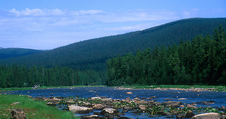
The Urals is simply dotted with numerous and beautiful rivers with a transparent cold water and picturesque rocky shores, and the most interesting rapids and rifts make them extremely attractive for outdoor activities. Mysterious rocks, keeping many traditions and legends, are surrounded by endless taiga. Bones of unseen animals, precious stones, gold, unknown rock paintings have been found here more than once ... The waterways of the Urals are mysterious and attractive, we will talk about several of them.
Ural mountains
First of all, we should talk about these mysterious mountains. The Ural Range stretches for two and a half thousand kilometers, from the icy shores of the northernmost ocean to the hot semi-deserts of the Republic of Kazakhstan, being the watershed of many rivers of the eastern and western slopes, the real border of the worlds of Asia and Europe. The ridge also separates the Russian and West Siberian plains. Rivers and are very numerous and have their own interesting features. There are more than five thousand rivers here, belonging to the basins: the Kara Sea, the Barents Sea, the Caspian Sea.
An interesting feature This region is a large number of artificial reservoirs - reservoirs, as well as ponds (more than three hundred with a total area of about 4.2 thousand square kilometers). Together with numerous hydroelectric power stations, the bulk of artificial reservoirs are part of the hydrotechnical plant network of the Urals.
Natural and climatic features
The huge length of the mountain range creates extremely diverse natural and climatic conditions for the rivers and lakes of the Urals, which inevitably affects their features.
The climate of the region is continental, with cold snowy winters and warm summers. The northern part of the Urals experiences a strong climatic influence of the northern seas and the Arctic Ocean, while the middle part of the mountain range is in the zone of influence of the Atlantic (especially the western part, where the largest number precipitation). The steppe and forest-steppe zones of the Ural Mountains are characterized by insufficient moisture, which directly affects the water abundance of the rivers flowing here, while the taiga and tundra zones, on the contrary, are characterized by excessive moisture.
in different parts of the Urals
In the Polar Urals, a small number of high-water rivers begin their run, such as the Khara - Matalou, Sob, Yelets and others.
Rapids, fast and large rivers of the Urals flow in the Northern and Subpolar parts of the mountains, such as the Pechora and its numerous tributaries (Shugor, Ilych, Kosyu, Podcherem, etc.). They replenish the Barents Sea with their waters. On the eastern slopes, the mountain rivers of the Northern Urals and the Arctic Circle are rocky, shallow, fast. They are rich in rapids and rifts. These rivers flow into the Malaya Ob, Northern Sosva and then carry their waters to the Kara Sea. The rivers in the north of the mountains are navigable for 5-6 months.

The Middle Urals, the Western Cis-Urals, the Eastern Trans-Urals - numerous rivers originate here. Here the streams that make up the water system of the Kama begin their run. It is the most powerful and full-flowing river in the region.
The rivers of the Southern Urals, like the Northern ones, have a very high flow rate. Their channels are characterized by a large number of rapids, rifts, waterfalls. The course of the rivers of the Middle Urals is much calmer and slower.
Features of rivers on different slopes of the ridge
The rivers of different slopes of the Ural Range also differ from each other. On the western slope, more precipitation falls due to the influence of the Atlantic, due to the western transport of air masses. Therefore, the rivers here are more full-flowing than on the eastern slope, where there is less moisture. Among the rivers of the western slopes, such large rivers of the Urals as Vishera, Belaya, Kama, Ufa, Sylva stand out. And on the eastern slopes, the largest are Sosva, Tavda, Iset, Lozva, Tura, Pyshma. The valleys of these rivers extend, as a rule, in the latitudinal direction. The Chusovaya River is unique, which, with its channel (the only one of all!) Captures both the western and eastern slopes of the mountain range.
Description Ural
The Ural River flows through Eastern Europe on the territory of the countries - Russia and Kazakhstan. This river carries its waters from Bashkiria to the Caspian Sea. Refers to the rivers of the Southern Urals. Length - 2428 kilometers. It ranks third in length in Europe after such waterways as the Volga and the Danube. Even the Dnieper is ahead in length. The Ural River originates at an altitude of 637 meters on the slopes of the Round Sopka (Uraltau Range) in Bashkortostan.

Then it flows along the edge of the Chelyabinsk region from north to south. It passes the cities of Verkhneuralsk and Magnitogorsk. At the same time, it receives the tributaries of the Gumbeika and B. Kizil. Encountering the plateau of the Kazakh steppe on its way, the Ural River abruptly changes its direction to the northwest. Further deviating to the west, then to the east, it reaches the Caspian Sea. The Ural River flows into the sea, breaking up into many branches.
The ancient name of the Ural
This river also has an ancient name. Until 1775, the Ural River was called Yaik. This name is official in Kazakhstan. In the Bashkir language, the river also has this name. It was first mentioned in the annals of the Russian people in 1140. It was renamed to Ural on January 15, 1775 by order of Catherine II. Then many geographical objects were renamed in order to erase the Pugachev uprising that flared from 73 to 75 from the memory of people.
Pechora River
It is one of the rivers of the Northern Urals. Its name means - a cave, is popular with fishermen and rafters. Its length is 1,809 thousand kilometers, Pechora flows through the territory of two subjects Russian Federation- the Republic of Komi and the Nenets Autonomous Okrug, has total area catchment area 0.322 million square kilometers. It flows into the Barents Sea, the annual flow is approximately 0.13 million cubic kilometers of water. The Pechora has a huge number of tributaries, about 35 thousand. In the river basin Pechora has 60 thousand lakes! Its main food is snowy.
The largest tributary of the Pechora is the Usa River, 500 kilometers long. Other major tributaries of the Pechora include the Northern Mylva, Unya, Lemyu, Velyu, Kozhva, Izhma, Lyzha, Neritsa, Tsilma, Pizhma, Sula, Ilych, Borovaya, Podcherye, Mustache, Shugor, Laya, Sozva, Kuya, Ersa, Shapkina. The most interesting of them for tourism are Unya (great fishing) and Usa (excellent rafting).
The largest marinas are Ust-Tsilma, Naryan-Mar, Pechora.
Before the confluence of the river Unya, the Pechora has a typically mountainous character. Its shores in this area are formed by pebbles, there are many rapids, rocky ledges, and rifts in the channel. And in its middle and lower parts, the nature of the river changes to a flat one. The shores are clayey or sandy. The waters of the Pechora spill in breadth, reaching a width of two kilometers. In this part you can see the branches, channels, Pechora Islands.

The area of the Pechora River is one of the hard-to-reach ones; the automobile network is extremely poorly developed here. For this reason, a lot of untouched natural corners have been preserved in the region, and one of the largest biosphere reserves in Russia has been organized between the tributary of the Pechora, the Ilych, and the Pechora itself.
Kara
Another of the most interesting rivers of the Ural Mountains is the one that flows in the Polar part of the ridge. Its length is 0.257 thousand kilometers with a basin area of 13.4 thousand square kilometers. The river flows through the regions of Russia: the Yamalo-Nenets Autonomous Okrug, the Nenets Autonomous Okrug, the Komi Republic.
It originates at the confluence of two rivers - Malaya and Bolshaya Kara. It flows parallel to the Pai-Khoi ridge. Throughout its length, the river flows mostly deserted and extremely picturesque places. Here you can observe several beautiful canyons, many rapids and waterfalls, the most famous of which, of course, is Buredan (9 kilometers below the confluence of the Nerusoveyyakha River).
The only one along the river. Kara settlement - pos. Ust-Kara - located near the mouth of the river. On its shores one can meet, perhaps, temporary dwellings of local peoples - plagues, and even then it is extremely rare.
Interestingly, the Kara Sea got its name from the Kara River, where in the eighteenth century one of the detachments of the so-called “Great Northern Expedition” under the leadership of S. Malygin and A. Skuratov got up for the winter.
Rafting on the rivers of the Urals
This is a very popular type of active rafting on the rivers: Ufa, Belaya, Ai, Chusovaya, Serge, Sosva, Yuryuzan, Rezh, Usva, Neiva. They can last from 1 day to a week. Rafting on the rivers of the Urals allows you to visit many sights without overcoming the distance on foot, but on a catamaran, trimaran or raft. Passing along the Serebryanka River, which then flows into the Chusovaya, water tourists repeat the path of Yermak. Also on Chusovaya its rocky shores are remarkable. The Belaya or Agidel river, which flows through the Republic of Bashkortostan, also attracts rafters. Combined hikes with visits to the caves are possible here. The Kapova Cave or Shulgan-Tash is widely known.

They raft along the Vishera, which is considered one of the most picturesque rivers in the Urals. It begins in the Vishera Reserve. It contains grayling, taimen, burbot, char, spike. The Pyshma River is notable for its rocks, on the river there is a resort "Kuryi" and the national park "Pripyshmenskiye Bory". The Kara River also has its interesting sights. This harsh northern river passes through several canyons and sometimes forms waterfalls, the largest is called Buredan. It is also very interesting for rafters. To the west of the river there is a meteorite crater with a diameter of 65 kilometers.
Ural (Bashk. Yayy ҡ , Kaz. Zhaiyk) - a river in Eastern Europe, flows through the territory of Russia and Kazakhstan, flows into the Caspian Sea.
The ancient name (until 1775) is Yaik. The hydronym ascends through the Turkic mediation to the ancient Iranian name: under the name *Daiks, the river is shown on the map of Ptolemy of the 2nd century AD. Currently, the ancient name of the river is official in Kazakhstan, as well as in the Bashkir language.
It is the third longest river in Europe, inferior in this indicator only to the Volga and Danube (even more than the Dnieper!).
On vintage European maps The Ural is called Rhymnus fluvius. The first mention in Russian chronicles in 1140.
Geography
It originates on the slopes of the Kruglyaya Sopka peak (Uraltau ridge) in the Uchalinsky district of Bashkortostan. It flows into the Caspian Sea.
Peter Rychkov in his book "Orenburg Topography" wrote:
Yaik has a peak behind the Ural Mountains on the Siberian Road, in the Kupakan volost, from a mountain called Kalgan Tau, which means: Extreme or Remaining Mountain in the Urals
This river separates Bashkirtsov from Kirgis Kaisaks
URAL RIVER BASIN
At the beginning, the Ural flows from north to south, meeting the elevated plateau of the Kazakh steppe, it turns sharply to the northwest, after Orenburg it changes direction to the southwest, near the city of Uralsk the river makes a new sharp bend to the south and in this main direction, meandering sometimes to the west, sometimes to the east, flows into the Caspian Sea. The mouth of the Urals is divided into several branches and gradually becomes shallower.
In 1769, Pallas counted nineteen branches, some of which were distinguished by the Urals 66,000 meters above its confluence with the sea; in 1821 there were only nine, in 1846 there were only three: Yaitskoye, Zolotinskoye and Peretaknoye. By the end of the 50s and the beginning of the 60s of the 19th century, almost no branches with a constant flow separated from the Urals until the city of Guryev itself. The first branch, separated from the main channel on the left, was Peretask, which was divided into channels Peretasknaya and Aleksashkin.
Even lower, the channel of the Urals was divided into 2 branches - Zolotinsky and Yaitsky, and both the first and second were divided into two mouths: Big and Small Yaitsky, Big and Old Zolotinsky. From the Zolotinsky branch to the east, another branch departed, Bukharka, which flows into the sea between Peretask and Zolotoy.
URAL RIVER NEAR THE CITY OF URALSK 
The Ural basin is the sixth largest among the rivers of Russia and is equal to 237,000 km². The length of the river itself is estimated at 2428 km.
The water horizon is at an absolute height of 635 m.
The fall of the waters of the Urals is not particularly great; from the upper reaches of Orsk, it has about 0.9 meters per 1 kilometer, from Orsk to Uralsk no more than 30 centimeters per 1 kilometer, and even less below.
SOURCE OF THE URAL RIVER - BASHKIRIA .jpg)
The width of the channel is generally insignificant, but varied. The bottom of the Urals, in the upper reaches is rocky, in most of its course it is clay and sandy, and within the Ural region there are stone ridges. Under the Urals, the bottom of the river is lined with small pebbles, which are found in somewhat large sizes near the White Hills; special pebbles made of dense clay, in addition, come across in some places in the lower reaches of the Urals (in the “Burned Onion”). The course of the Urals is quite tortuous and forms a large number of loops. The Urals, with a small fall in water, very often changes the main channel throughout, breaks new passages for itself, leaving deep reservoirs, or "oxbow lakes" in all directions.
Thanks to the changeable course of the Urals, many Cossack villages that used to be near the river later turned out to be on oxbow lakes, the inhabitants of other villages were forced to move to new places only because their old ashes were gradually undermined and demolished by the river. In general, the Ural valley is cut on both sides by oxbow lakes, narrow channels, widened channels, lakes, small lakes; during the spring flood, which occurs from the melting of snow in the Ural Mountains, all of them are filled with water, which is kept in others until the next year.
In spring, rivers and rivers carry a lot of melt water to the Urals, the river overflows, overflows its banks, in the same places where the banks are sloping, the river overflows by 3-7 meters. The Urals are not very navigable. Sturgeon, stellate sturgeon, carp, catfish, pike perch, bream, catfish, and chubak are found here. Also from the river is a water supply to the oil fields.
RESERVE SEVEN BROTHERS IN THE CHELYABINSK REGION 
tributaries
Most of the tributaries flow into it from the right side, facing the Common Syrt; of them are known: Artazym, Bolshoy Kizil, Tanalyk, Guberlya, Sakmara, Zazhivnaya, lost in the floodplain, not reaching the Urals, in the meadows between the villages of Studenovsky and Kindelinsky, Kindel and Irtek within the Orenburg region; in the West Kazakhstan region below the Irtek, several shallow rivers flow, including the Rubezhka, at the mouth of which there were the first villages of the Yaik Cossacks, the most water tributary on the right is the river. Chagan, flowing from the General Syrt.
From the left, the rivers flow: Gumbeika, Sununduk, Bolshoi Kumak, Or, Ilek, Utva, Barbasheva (Barbastau) and Solyanka, which is noticeable only in spring and dries up in summer.
Border between Asia and Europe
Memorial sign "Europe - Asia" on the banks of the Urals in Verkhneuralsk.JPG)
Contrary to popular belief, the Ural River is a natural water border between Asia and Europe only in its upper reaches in Russia. The border passes in Verkhneuralsk and Magnitogorsk, Chelyabinsk region. In Kazakhstan, the geographical border between Europe and Asia runs south from Orsk along the Mugodzhary ridge. Thus, the Ural River is an internal European river, only the Russian upper reaches of the river east of the Ural Range belong to Asia.
Preliminary results of the expedition of the Russian Geographical Society conducted in April-May 2010 in Kazakhstan showed that drawing the border between Europe and Asia along the Ural River, as well as along the Emba, does not have sufficient scientific grounds. The fact is that south of Zlatoust, the Ural Range, having lost its axis, breaks up into several parts, then the mountains gradually disappear altogether, that is, the main landmark when drawing the border disappears. The Ural and Emba rivers do not share anything, since the terrain they cross is identical.
URAL RIVER - ORENBURG CITY 
URAL RIVER IN ORENBURG REGION
The largest river in the Orenburg region is the Ural (in ancient times, Yaik), the main part of its flow is formed in the Orenburg region.
Two other large rivers - Sakmara and Ilek - originate in Bashkiria and Kazakhstan, respectively, but flow into the Urals within the Orenburg region. The Ural is the third river in Europe in its length; in length it is second only to the Volga and the Danube. Even the Dnieper is shorter than the Urals by 249 kilometers.
The Ural is the main water artery of the Orenburg region. The Ural River crosses the Orenburg region from east to west, flowing through 10 districts of the region for 1164 km. The main feature of the river is the uneven flow. In the spring flood, the Urals turns into a huge watercourse, filling the entire floodplain 6-8 km wide.
The Ural is the third river in Europe in its length; in length it is second only to the Volga and the Danube. Even the Dnieper is shorter than the Urals by 249 kilometers.
The two first large Orenburg tributaries of the Urals, Tanalyk and Suunduk, currently flow into the Iriklinskoye reservoir, forming bays of the same name. The Tanalyk River, 225 km long, originates in the spurs of the Uralau, then crosses the Irendyk. The average water flow in Tanalyk does not exceed 1.0 m3/s.
In the area of the city of Orsk, two more significant tributaries Bolshoy Kumak and Or flow into the Urals on the left.
Throughout the entire length from the Iriklinsky reservoir to the mouth of the Sakmara, the Ural receives only one significant tributary on the right - Guberlya.
The largest left-bank tributaries of the Urals from the city of Orsk to the mouth of the Ilek - Kiyalyburtya, Urtaburtya, Burtya, Berdyanka, Donguz, Chernaya - are typical steppe rivers with short but violent spring floods. The last two of them - Donguz and Chernaya - practically dry up in the middle of summer due to the construction of large reservoirs on them.
The Ilek River is the largest left-bank tributary of the Urals. Below the Ilek, the Ural receives three more significant tributaries on the right: the Kindel, the Irtek, and the Chagan. The last of them flows into the Urals already outside the Orenburg region.
Near the city of Orsk, the Or river flows into the Urals. In the "Gorge" the river almost straight cuts through the Ural Range, even lower begins a 40-kilometer section of the Khabarninsky Gorge. On this segment, the Ural receives the waters of the mountain rivers Guberli with Chebakla and Kinderli on the right, and on the left - Ebita, Aituarka and Alimbet.
On the map, the Ural basin resembles a tree bent to one side with a thickened trunk in the middle and very short branches. Only the right tributary - the Sakmara River, which flows for a long distance parallel to the Urals, has a relatively dense branched network of tributaries.
The Ural River is not navigable, its width is 50-170 m, the depth is 3-5 m, the flow speed is 0.3 m/s, the bottom is sandy, there are no fords. The shores are mostly steep, the height of the cliffs is 5-9 m. The floodplain of the Urals is wide - 10-12 km, meadow, with significant forests, a large number of pegs, rare shrubs, indented by numerous rivers, oxbow lakes and channels, many lakes.
In ancient sources, the name of the Ural River is found - Likos, Daiks, Daih, Dzhaikh, as well as Ruza, Yaik, Yagak, Yagat, Ulusu, Zapolnaya River. The name of the river Yaik and consonant with it Daiks, Daih, Yagak and so on. have been dating for about two thousand years. Now it is difficult to say what the word "Daiks" meant in the time of Ptolemy, when the Iranian-speaking tribes of the Sarmatians were still roaming in the Ural basin. The Russian form "Yaik" is first found in the Russian chronicle of 1229.
It is considered a derivative of the common Turkic stem "Zhaik" with the meaning "wide riverbed" or "widely overflowing".
GOLDEN AUTUMN ON THE URAL RIVER .jpg)
THE LARGEST TRIBUTIES OF THE URAL IN THE ORENBURG REGION
Sakmara riveris the largest tributary of the Urals. The length of Sakmara within the Orenburg region is about 380 km.
In the upper reaches of the Sakmara it is a typical mountain river with steep banks and narrow terraces, in the middle and lower reaches its valley is wide, asymmetric with well-defined two terraces and a populated floodplain.
Ilek river- the largest left-bank tributary of the Urals (623 km). Its origins are in the Mutojar mountains. In terms of catchment area (41 thousand km 2), the Ilek is one third larger than the Sakmaru, but carries 2.5 times less water than the most abundant tributary of the Urals (annual flow rate is 1569 m 3).
The Ilek River has a wide, well developed valley with two floodplain terraces. The size of the Ilek valley is sometimes not inferior to the Ural one. The Ilek floodplain abounds with numerous channels and oxbow lakes.
FOREST-STEPPE VALLEY OF THE URAL RIVER .jpg)
SIGHTS OF THE URAL RIVER
alabaster mountain
The next mountain on the left bank of the Urals is Alabastrovaya, located 75 km by land and 147 km by water above Uralsk. The mountain is half eaten by a quarry - alabaster has been mined here for a long time. To the east of the former quarry stretches a high slope with marl screes. Its middle part is overgrown with thick oaks for these places, as well as birch, aspen, poplars with bird cherry, viburnum, goat willow in the undergrowth.
Three kilometers below the Alabaster Mountain, the Ural is washed by the not so high Dolinsky Yar, composed of sandstones, flagstones, and conglomerates. Numerous oaks and birches climb along its slopes.
We sail along the Urals for another 30 km and on the left bank near Aula-Aksai we again notice chalk outcrops. But the chalk and marl slopes reach their greatest height somewhat lower, on the Kitayshinsky Yar.
Below the mouth of the Rubezhka River and the village of Rubezhinsky, where the navigable section of the Urals begins, another hill appears on the left bank. The river washes it twice. For the first time, immediately after the impetuous reach of Uporny Yar, where the Urals, hitting a high sheer marl scree, makes a turn of almost 180 °. Here the river reaches the fastest rift below Orenburg, Saurkin, and splits into two channels. After 5 km, on the way of the Urals, there is a second high marl cliff - Polousov Yar. Both Yar-cliffs - Saurkin and Polousov rise above the river by more than 50 m. Their slopes are complicated by giant landslides. In a kind of amphitheater between them lies the natural phenomenon of the Ural valley - the Krasnoshkolny relic forest. One of the slopes of this huge amphitheater is overgrown with a magnificent oak forest, under the cover of which hazel, or hazel, and a forest apple tree are sheltered. The herbage of the oak forest consists of bracken fern, May celandine lily of the valley..JPG)
treasure coast
This seemingly inconspicuous tract on the banks of the Urals deserves the most careful attitude. It is not for nothing that folk wisdom called it the Treasure Coast - this is one of the most remarkable places on the entire right-bank slope of the Ural valley from Orenburg to Ilek.
If before the mouth of the Ilek the steep bank near the Urals is right, then below the Ilek the left bank is much more often steep, which belongs entirely to the Ural region. In the Ilek-Uralsk section, the river washes away at least six hills with salt domes at their core, and chalk, marl, white clay, ferruginous sandstones and flagstones on the surface. These. the uplands form a single chain of small mountains stretched along the junction of the Common Syrt and the Caspian lowland. The Urals manage to break through this chain and rush to the south only to the south of Uralsk, leaving the dome seventh in a row from Ilek - Chalk Hills on the right.
The first on the way of the Urals is the Utvinsky Cretaceous Island. It is located slightly above the mouth of the Utva River, 6-10 km northeast of the village of Burlin, Ural Region. During the spring flood, Utvinsky Island is surrounded on all sides by water, from the north by the Urals, from the west and southwest by Utva, from the south and east by Lake Bumakol and chalk channels connecting it with the Urals. Only by mid-June is the overland road to this unusual island usually established..jpg)
At the foot of the ancient ravines
The steep shores in the Urals are called ravines, and the high san of them with outcrops of bedrocks are known among local residents under the names such and such a mountain, such and such a forehead, coast. These are usually remarkable in landscape geological terms steep slopes of the river valley, which have the value of unique natural monuments.
One of them is located on the right bank of the Urals between the villages of Pervaya and Vtoraya Zubochistka, Perevolotsky District, Orenburg Region. The steep and high coast of the Urals here is complicated by several cirque-like landslides, which were formed as a result of downslope displacements of blocks of sandy-argillaceous deposits associated with the activity of groundwater.
But there is something else interesting here. On this segment, the Ural lobe crosses a subsided section of the earth's crust with a width of about 1 km. On both sides, this is a lowering of the boundary by layers of Permian red-colored and variegated rocks inclined in different directions. In mountainous countries, such phenomena are called grabens; as a result of them, rocks of different ages and compositions appear on the same horizon. This kind of graben was formed not in the mountains, but on the plains - in a depression, the sides of which are composed of dense Permian and Triassic rocks that formed more than 200 million years ago. Here, gray and white clays, marge, sandstones of the Cretaceous and Paleogene periods have been preserved from erosion. Their age is from 50 130 million years. The geological structure of the Ural coast is complicated in this area by landslide processes. As a result, the coastal slopes of each other are replaced by variegated sandy clays of various shades, marls, calcareous tuffs, ocher scree. It seems that all the colorful ranges of yellow, gray-green, brown, red colors were collected by nature in this kind of collection of sedimentary rocks..jpg)
Lakes of the Ural floodplain
There are many wonderful landscape features near the lakes of the Ural floodplain. For example, the habitat of the most ancient and amazing relic that has survived to this day, the chilim, has been preserved here. Its continuous thickets, covering the water surface with rosettes of leaves, have been preserved on the lakes of the Ural floodplain below Orenburg: Bespelyukhin, Orekhovy, Bolshoi Orlovo. Old Ural, Linden, Nuts, Jilimny, Forpostno and many others. Several names have been assigned to this plant: chilim, rogulnik, and among the people it is also known as water or devil's walnut, horned walnut, live anchor, water chestnut.
Fossilized remains of chilim fruits have been found in deposits of the Cretaceous period. This means that it has been inhabiting the fresh water bodies of the Earth for more than 70 million years. But at present, chilim thickets have been preserved in few places. It is noteworthy that, forming continuous thickets on one of the lakes, it no longer settles on neighboring lakes, and sometimes even for tens or hundreds of kilometers around. The foregoing testifies to the relic nature of the chilim preserved only under certain environmental conditions. In recent years, chilim lakes have been taken under protection in Mordovia, Bashkiria, in the Altai Mountains, Far East and in many other parts of our country. Chilim is listed in the Red Book.
Jasper Mountain Colonel
.jpg)
We find a description of this mountain by P. S. Pallas, who visited here in 1769. He wrote: “Beyond the Or river, a mountain range begins, in which the best rocks of jasper stone are visible. The layers in this mountain, as well as in the jasper mountains lying near Yaik, for the most part descend into the depth from the western to the eastern side. The local flask has a lot different colors. The best jasper, especially in a large collapse, is sometimes coffee-colored, sometimes white with red and yellowish stripes. There are also pieces on which herbs and trees are depicted. There are Kyrgyz graves on every hill. Nowhere can you find the best pieces of local jasper as on these graves, and it seems that the action of the sun produced a color much better outside than inside the stone. In the vicinity of Orsk already at that time there were several quarries.
Academician A. E. Fersman, describing minerals Soviet Union in the book “Journey for a Stone”, on the title of the book he placed six pieces of stone, namely the Orsk jasper, to which the scientist devoted many enthusiastic lines: “It is difficult to give an exhaustive description of this jasper - its pattern and color are so diverse, we know over two hundred varieties of jasper area, and the best drawings and colors are related to the jaspers of this field ... It seems to me that we are in a wonderful art gallery. Not every artist will be able to convey such combinations of tones and colors that nature itself scattered here with a generous hand. It’s like a stormy sea: its greenish waves cast a reddish reflection of dawn, here is a white edge of foam, and here are rocky shores ... ”and further:“ ... Or jaspers are undoubtedly the national wealth of the country.
In addition to Mount Colonel, along the Urals there are a number of other places where jasper is born. Many of them are still not widely known; they contain the future glory of the Trans-Ural jasper belt.
FISHING AND FISHING ON THE URAL RIVER
.jpg)
Fish spawning in the Urals
In 1981-1983 The conditions and efficiency of sturgeon spawning upstream of the city of Uralsk were studied by the Orenburg Laboratory of Landscape Reclamation and Nature Protection. The author happened to lead the work of this expedition.
Observations have shown that practically all non-silty areas of the river bottom with solid ground serve as spawning grounds for sturgeons in spring. It was found that spawning is most effective in large fields of channel and beach Mechnik, gravel and cemented shell rock, where the flow velocity in high water reaches 2 m/s, preventing silting of the soil and laid eggs.
On the 315-kilometer section of the river from Uralsk to Ilek, the expedition studied several types of spawning grounds. The most common of them were riverbed beaches. As is well known, they are formed along convex coasts, where thick strata of coarse-grained material accumulate. The excess of beaches above the low water level of the river reaches 4 m, the width is 40-120 m. The length of the Ural beaches, depending on the radius of the bend, ranges from 200-300 m to 2 km. The longest beaches in the Ilek-Uralsk section are Kambavsky Sands (below the village of Yanvartseva) and Trekinsky Sands (above the city of Uralsk). The most valuable in terms of quality are Verkhnekirsanovskiy and Aksuatskiy beaches with a dense pebble coating, located respectively at the 179th and 36th kilometers above Uralsk.
UPPER URAL RIVER
.jpg)
White salmon in the Urals
The whitefish is a representative of salmon fish, very close to the whitefish. It reaches 120 cm in length and 20 kg of weight. In its appearance, it somewhat resembles the well-known asp. The white salmon is a predator, but in the Urals it hardly eats. The whitefish enters the river for spawning no more than twice in a lifetime. She lives up to 11 years.
The closest relative of the white salmon, the nelma, lives in the basin of the Arctic Ocean. It was from there, according to scientists, that at the end of the Ice Age, along the chains of lakes, she moved through the Kama and the Volga to the Caspian Sea and, having changed somewhat, became a whitefish.
White salmon is the most valuable commercial fish, but now its catch is prohibited everywhere. Through the efforts of scientists and fish farmers, it was possible to maintain its numbers artificially. At the foot of the dam of the Volgograd hydroelectric power station on the Volga, gravel spawning grounds are poured for the white salmon. The only natural spawning grounds for this fish are in the Urals.
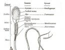
One of the little-known inhabitants of the Urals and its tributaries is the lamprey. It belongs to the oldest class of cyclostomes. She has a snake-like body about 0.5 m long, weighing up to 260 g. Lamprey has a number of features that are not characteristic of other fish species. Her mouth is a deep funnel-sucker, at the bottom of which is a tongue, which, like a piston, either extends or retracts. The tongue serves as a drill that pierces the skin of the fish. The lamprey has a third eye, the parietal, located near the nasal opening. There is no lens in it; with its help lampreys perceive only light. They inherited this organ from their ancestors, widespread in the Silurian and Devonian periods, that is, more than 400 million years ago. Thus, the lamprey can be considered a kind of "living fossil".
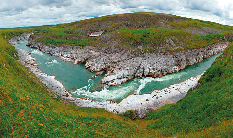
URAL RIVER, GUBERLIN MOUNTAINS 
Stellate sturgeon in the Urals
The most numerous sturgeon in the Urals is the stellate sturgeon. The Ural-Caspian fisheries produce up to 70% of the world's stellate sturgeon catches. The main spawning grounds for stellate sturgeon are located in the lower reaches of the river. A small amount of stellate sturgeon rises above Uralsk, reaching Ilek and even Rassypnaya. The stellate sturgeon is represented mainly by the spring form. It spawns later than other sturgeons at water temperatures above 12-14°C. The average length of the Ural sturgeon is about 120-140 cm, weight is about 10-15 kg.
The only living sturgeon species in Uralsk is the sterlet. It is found throughout the lower and middle reaches of the river - everywhere very rarely. The usual dimensions of the Ural sterlet are: length about 60 cm, weight 2.5 kg.
In addition to sturgeon, other species of anadromous fish are found in the Urals. The most interesting of them are white salmon and lamprey.
White salmon is an endemic of the Caspian basin; it is not found anywhere in the world, except for the Caspian and its tributaries. More recently, the whitefish was threatened with complete extinction. After the construction of a cascade of Volga hydroelectric power stations, it almost completely lost its natural spawning grounds located in the Ufa River. In the 1950s and 1960s, a small herd of Caspian white fish was supported by spawning grounds in the Urals.
The spawning grounds of these fish in the Urals have not been precisely established. The white salmon enters the river from the Caspian Sea from October to March. Its spawning takes place in October - November on gravel and pebble soils. In the early 80s, individual specimens of the whitefish were caught in the Urals near Orenburg, in Sakmar, Bolshoi Ik. One of the spawning grounds for the whitefish is probably located under the Mayachnaya mountain in the Belyaevsky district, 200 km above Orenburg. The number of white fish spawning in the Urals is apparently estimated at several hundred specimens, since scientists now count about 20 thousand individuals of this species in the entire Caspian herd.
TRIBUTIVE OF THE URAL RIVER - THE GUBERLYA RIVER

Anadromous fish in the Urals
It takes a lot of time to restore strength and develop a new portion of reproductive products for re-entering the river for spawning: females - 5-6 years, males - 3-4 years. Therefore, despite the long life span (up to 30 years or more), each producer can enter the river only a few times in his life.
Every year, huge hordes of migratory fish rush to the Urals. Their forward detachments reach Ilek, Orenburg and even Orsk. Ichthyological observations 1981 - 1983. it was established that the largest specimens of sturgeons rise to the middle of the river reach. This means that the middle course of the Urals is of decisive importance for the conservation of large-sized sturgeon specimens.
The largest fish in the Caspian basin is the beluga. In the 20s of our century, fish weighing up to 12 centners were caught in the Urals. In former times, larger specimens were also caught. The usual weight of beluga spawning above Uralsk is 150-300 kg for females and 50-90 kg for males. Belugas weighing 600 kg or more are still found to this day.
Sturgeons in the Urals
Sturgeons are freshwater fish, many of them have adapted to live in brackish and even marine waters. But not a single species of sturgeon can breed outside freshwater reservoirs. Sturgeons have reached the greatest abundance in the Caspian Sea basin, where 5 out of 23 species of sturgeon fish of the world are represented - these are beluga, sturgeon, spike and stellate sturgeon, which have mastered the food resources of the sea, where they spend most of their lives, Sterlet, which is a non-water species, that is, never does not leave the river.
Beluga, sturgeon, thorn and stellate sturgeon of the Caspian are anadromous fish. They regularly migrate from the Caspian Sea to the rivers for breeding. In anadromous fish, winter and spring races are distinguished. Winter crops enter the river in summer and autumn, and after overwintering, they spawn. Spring birds enter the river in winter and spring and spawn in the same year.
Anadromous fish in the river usually do not feed or feed very little. Overcoming the river current during spawning migrations, prolonged stay in the river and the spawning process itself lead to severe exhaustion of producers. It has been established that stellate sturgeon and sturgeon lose up to 30% during spawning migration, and beluga - up to 50% of their weight. And, as a rule, the more energy reserves a particular individual has, the larger it is, the higher up the river it can and tends to rise.
FISHING ON THE URAL RIVER
This time we decided to go to Krasnaya Luka with the whole family. She attracted my father by the fact that he, a lover of catching podust in wiring, always left here with good prey. Unmarked place - not far from the city, rarely visited by anglers. It is also convenient because in the afternoon there was a shadow under the ravine, saving from the exhausting heat. Above, a hollow, overgrown with green ants, approached the very shore. There was also a group of silvery poplars.
The sun was still high when we arrived. A man was climbing heavily towards us, bending under the weight of a backpack from which carp tails protruded. We looked at each other silently. He looked unkindly and contemptuously at us and our gear. I naively asked, running my finger over the quivering sazan tail:
- Did you fish here? For fishing rods?
- Here, but not about your honor, - he answered and, grumbling: - Fishermen to me too, - turned onto the path. We could hope that the parking lot where the carp was fattening was open; on the good catch- hardly: where are we, really, with our fishing rods. And there was no experience.
In the morning, when the pebbles of the shore scorched my feet with cold, I took my short donkeys and went upstream, where the ravine went steeply into the water. Looked around. There were cigarette butts all around. Broken shells gleamed like mother-of-pearl. On a trampled small area, holes from fishing rods. There was no doubt: that unfriendly uncle was fishing here yesterday. The rapids, hitting the sheer wall of the ravine, retreated at a slight angle to the fairway, forming a small backwater. In it, the water flowed evenly, calmly, which spoke of great depth. Unwinding my unsightly fishing rods, designed for a trifle, I shuddered: fifteen meters away, where the shadow of the yar ended, a carp jumped out. Then more. And further. Gold ingots of fish marked the surface of the water with divergent circles. The breeze carried the whitish wisps of mist into the willow matted with dew. I threw ... And then the end of the rod trembled, bent down, frozen in this position for a few seconds. Then he straightened up and nodded slowly, widely ...
I don't remember how I pulled the fish out. Everything happened as if in a daze. But it was him, my first carp. I ran along the shore, slipping and stumbling, clutching the fish tightly to my chest with both hands, and shouting triumphantly:
- Got it! Caught!
Now, many years later, I ironically, but with satisfaction, laugh at myself: no, perhaps I didn’t catch the carp, but he caught me and so that I can’t escape all my life!
In the Urals, there are two types of carp: the anadromous - the one that rises upstream from the sea, and the local one. The guest is silvery-pale in color, long, running. His own - the color of pure gold with an orange tail fin, humpbacked, high in the back, shorter. This is a handsome man. He is much stronger, more careful and ... fatter than the passerby.
There used to be a lot of carp. They caught him easily and without exciting sporting interest: just think, he broke loose, another one will grab it! Twenty years ago, the fishing collective farms of the Guryev region were not well equipped technically, and there were not enough people in the fisheries.
Now the picture is quite different. At the mouth of the Urals, day and night, from both banks, dozens of seines scoop up fish that go to spawn. If earlier carp reached Orenburg, now it does not reach Uralsk every year. Much less of it was in the river. And the more honorable is the trophy when you catch not a thin, hungry alien, but a violent one, much more for any tricks of the “owner”.
The common attachment for carp in May and June is forest worms, which are very numerous in the local coastal forests, which are flooded during high water. Later, if it rarely rains and there are few worms, shells of different colors serve as a nozzle: white, yellow, pink, gray with black, reddish. However, a combined nozzle is considered the best: a shell or a piece of fish fillet and an earthworm. At the end of August and in September it is good to fish for bread, mainly in the backwaters, where the current is not strong.
The second "rank" fish in the Urals is asp. Who has not seen his robbery raids on a trifle fattening on the shallows? Who hasn't admired his powerful bursts in the suvod, under the yar? But it is not so easy to catch this cautious fish. However, I don’t know how it is in other water bodies, but in the Urals, catching asp is not so difficult.
I find that asp is not picky about the bait. In my practice, there was no case that he refused a live fish, a frog, a grasshopper, a tassel of worms, an oscillating lure.
I remember such a case. Somehow at the end of October, after unsuccessful fishing in a quarry (deep hole), I was returning through the Perevalochnaya grove. A gusty cold wind blew, with occasional drizzling rain. The river was surging with steep waves. I do not remember how I got to the coastal sand. Somewhere in my mind flashed: “My hopes for biting blue bream and bream in the quarry did not come true. Maybe a zander will take here? In this place, a two-meter depth, a smooth moderate current. Without thinking for a long time, I baited the donkey with a piece of fish and abandoned it. Soon the fishing line was stretched, the tip smoothly bent down to the water. The subsection is empty.
He threw it again, and again a bite immediately followed. This time I felt that a large fish was resisting in the depths. Who? Sudak doesn't behave like that. This is a large-mouthed asp with a golden rim around the eyes. Following him, he pulled out another one and that was it: there were no more bites. Accident? A month ago, even two weeks ago, asp was caught on a lure, which was thrown under a ravine, where insects fell, and bleaks scurried in the upper layers of the water. Now the small fry have gone to quiet water, hid in snags, the grasshoppers have disappeared, and the predator has nothing to do here. It is just as useless to look for him on the rifts: he does not chase the fry, does not beat, does not make himself felt. And yet, as it turned out, there are asps in small places, although my trophies at that time could not be considered conclusive evidence.
If on a quiet day we look at the river from a hill, we can distinguish yellow and dark spots. These are underwater shallows, alternating with pits. Sometimes the shallows are in the form of an arc, parallel to the shore and abruptly dropping into the water. In such places shallow holes are formed. The crest of the shoal (grivka), descending gently towards the middle of the river, is clearly visible. Behind the manes are the favorite places of the asp. Here he hunts minnows.
And so I came here again. Now with spinning. It was a quiet day, and the bottom relief was clearly visible. I made several casts: no chase, no exits. The spinner lay about a meter further than the crest. I had to increase the casting from 20 m to 40-50. And as soon as the metal bait touched the water, a sharp jerk immediately followed - breakers appeared on calm water. So in three hours I caught a few asps.
And again doubt: the reason for luck, perhaps in favorable weather - it is quiet, sunny, and the asp went to the shallows. A few days later I was fishing again in these places. This time a strong western wind was blowing, steep waves were moving along the Urals, heavy clouds hung low above the ground, ready to burst into rain or snow. It had rained all night the night before, and the sands, previously golden, had turned gray and gloomy. Cold, damp. But the asp still grabbed the lure. And large - up to 2-3 kg. Then I made another discovery for myself: in autumn, predators do not walk around, as in summer, but stand in one place. And as soon as the lure appears near their parking lot, one of them rushes at her.
I even mentally drew a circle for myself on the water: hit it - there is an asp, missed it - throw it again. The most catchy spinner is of medium size, of the Baikal type, painted on the inside with red lead. But when fishing with spinning on the sands, you need some skill. Do not forget that you are fishing on the rocks. Immediately after casting, you need to take a few steps back in order to quickly select the fishing line sagging due to the wind, while winding it onto the reel. At the same time, the rod is raised almost vertically, so that the reel is not at chest level.
I love fishing with a fishing rod, spinning, but still fly fishing, in my opinion, is the most exciting, exciting and interesting form of fishing. At the same time, it is important that there is no need to carry a bunch of rods with you, main and spare sinkers for donks, bags with worms, shells ...
Of course, you have seen more than once in quiet water, in the shade of trees hanging over the water, leisurely strolling ides and chubs. It was worth waving your hand, and the fish seemed to melt in the depths. Was:. — and no. I can’t even believe that just not far from evil:: there were red-haired handsome men. Catching them with a simple bait in August is very difficult. The most delicious nozzles are useless. And then fly fishing comes to the rescue.
In the evening, before sunset, you rush into a hollow, densely overgrown with grass: dew appears earlier in the lowland. And the grasshoppers, whose wings become damp, are helpless. Now it is no longer difficult to quickly fill the jar with them. Over the shoulder - a bag for fish, in the hand - a light three-meter rod. That's all the equipment. Convenient, easy.
While it is light, you choose a site (so that there are no bushes on the shore) with shallow depths, with sand, pebbles and wait. You watch how, squeaking, flying from hillock to hillock, the wagtails settle down for the night. Behind them, silent crows appear in the evening. Next - magpies. The dawn is quite good. Silence envelops like cotton wool. Somewhere a fox is yapping, an owl is hooting, a large fish is beating. A light wind either brings a wave of tart meadow infusion, or dry heat from the steppe. But in the west, a scarlet strip is already barely noticeable. It's time. You go down to the water. You unwind the line and pull it out meter by meter so that there are no rings or kinks. Meadow grasshoppers are small, and therefore you put several pieces on the hook. Then smoothly tilt the rod back, wait a second or two for the line to fly out to its full length. Swing forward—and nine meters away from you, a nozzle falls into the water. Letting the current pull the fishing line, you pull towards yourself, slightly taking it to the side.
The moon rises, and a golden path lies on the river. Nightingales are flooding in the coastal forest. And the hand over and over again sends a fishing line with a nozzle from behind the back downstream, where a trifle is busy near the shore. Another throw, another ... And suddenly a blow! Shy away to the sides. small fry. Something alive and heavy is pulling the line. Finally, it comes to the realization that there is a fish on the hook. Which one is not difficult to guess: the chub is immediately thrown out of the water; the asp goes into the depths; in its own way, briefly twitching, the ide resists.
The summer night passes unnoticed. Behind about three kilometers of the way through the rubble and steeps ... After all, when fishing with fly fishing, it’s like this: you caught one or two ide - and move on. In the meantime, the sun shows its sleepy eye over the forest, a pink mist rises over the river. Sleepyhead. Silence. And fatigue... There are several ides and chub in the bag. Time to go home. Last compulsory procedure- bathing. Reluctantly, you throw off your clothes and, after a pause, rush into the water. It seems that there was no sleepless night, severe fatigue. Refreshed, vigorous, as if the river poured into you part of its inexhaustible energy, you walk along the road. The way back seems shorter, easier.
The Urals is rich in fish. There is a lot of it in lakes, oxbow lakes, steppe rivers. You can get to any designated place by bus or car, which now go to all districts of the region.
REST IN THE URALS
There are many old women in the river valley. The coasts are mostly steep.
The winding course of the river often changes, as a result, it often turned out that the villages that stood on the river eventually ended up on the oxbow lake or even far from the water.
There are several reservoirs on the river, the largest and most beautiful among them is Iriklinskoe.
In the past, the Ural was a large river, it was navigable. In particular, there was water transport from Orenburg to Uralsk. However, every year in the summer the river becomes shallower, it can be forded, and navigation is a thing of the past. The causes of shallowing are mainly rooted in the plowing of the steppes and the destruction of forest belts.
Scientists and public figures sounded the alarm. Plans began to be developed to save the river, restore its ecosystem and fill it with water, ecological expeditions are organized every summer. Hopefully the river will be saved.
And although the Ural River has lost its navigable value, it is quite suitable for tourist rafting. Of course, it is not comparable in beauty with such rivers as the Chusovaya or the Ai, but even here you can have an interesting time and have a good rest.
In some places along the banks of the Urals you can find rocks. The Ural River is especially beautiful after Orsk. Here the river flows into the gorge along the Guberlinsky mountains, the length of this section is about 45 kilometers.
In the Urals, you can see such beautiful geological and landscape natural monuments as the Iriklinskoye Gorge, the Orsky Gates, the Poperechnaya and Mayachnaya mountains, the Nikolsky open pit and others. There is good fishing on the river. In the past, the Ural River was famous for sturgeons. In the late 1970s, the share of the Ural River in the world sturgeon production was 33 percent, and in the production of black caviar - 40 percent! .. Unfortunately, now the sturgeon population has decreased by more than 30 times.
The government of the Orenburg region is pinning its hopes on the development of water tourism on the Ural River. In particular, a water route for kayaks with a total length of 876 kilometers has been developed (523 km from Iriklinsky to Orenburg, 352 km from Orenburg to Ranniy). Rafting on this route is designed for 28 days.
However, it is not necessary to raft, you can just come on the weekend to the banks of the Ural River, relax after a hard day and go fishing.
________________________________________________________________________________
SOURCE OF INFORMATION AND PHOTO:
http://prirodaurala.ru/reka-ural/
http://www.orenobl.ru/priroda/ural.php
Wikipedia site.
http://www.inforybaku.ru/rybolovnye-puteshestviya/460-ural-ural-reka.html
http://www.kraeved74.ru/
Ural is a river in the Caspian Sea basin. It flows through the lands: the Republic of Bashkortostan, the Chelyabinsk and Orenburg regions, as well as the Republic of Kazakhstan. Find out where the river flows here.
The length of the river reaches 2.42 km (in terms of length, this is the third indicator in Europe after the Volga and Danube). First, the Ural flows from the Bashkir territories to the south. Here the river can be called a mountain one - the streams in the upper reaches are so strong. Then the waters flow into the Yaik swamp, from where the Urals come out wide. In some places, the width of the river reaches 5 km.
Crossing Verkhneuralsk, the Ural turns into a typical flat river, giving way to relief in the Guberlinskie mountains. Near the city of Uralsk, where the river enters into full ownership of the Kazakh steppes, its valley exceeds tens of kilometers. At the mouth, the river is divided into two branches - Yaitsky and Zolotoy, on which navigation is organized. Visit attractions.
Excursion into the history of the Urals
The old name of the hydrogeological object is Yaik. The origin of the hydronym goes back to the ancient Iranian language. Under the name Daiks, the river was designated by Ptolemaic geographers in the 2nd century AD. The mighty Ural river received its modern name thanks to the decision of Catherine the Great. Pushkin, in his history of Pugachev, said that Yaik, according to the decree of Empress Catherine II, was renamed the Urals, as it comes out of the mountains with the corresponding name. An outstanding Russian poet and writer also mentioned that the Ural is the third longest river in the Old World, second only to the Danube and the Volga.
In ancient European maps, the ancient hydronym Rhymnusfluvius is found. In the annals of the Russian principalities, the river was first mentioned in the middle of the 12th century. Then Prince Mstislav managed to drive the Polovtsy beyond the Volga, Don and Yaik.
Empress Catherine the Great ordered to change the name to Ural. In 1775, the tsarina suppressed a large-scale peasant unrest led by Pugachev. What prompted this decision remains a mystery. However, historians are sure that Catherine II decided to eradicate the story of Pugachev, the Bashkirs and the Yaik Cossacks, who were directly involved in the uprising. In the Kazakh and Bashkir languages, the name of the river did not change, but this in no way could affect the popularization of the new hydronym.
Ural separating two continents
Contrary to popular belief, the Ural River in its upper reaches is a natural water boundary between the Asian and European continents. The symbolic border passes in the cities: Magnitogorsk and Verkhneuralsk in the Chelyabinsk region.
In the Republic of Kazakhstan, from a geographical point of view, the border between the continents runs from the city of Orsk to the south to the Mugodzhary mountain range. Thus, we can say with confidence that the Ural is a European river, and only the upper reaches of the eastern ridges of the Ural Mountains in Russia can be classified as Asia.
In early 2010, experts from the Russian Geographical Society conducted a large-scale scientific study of the river in Kazakhstan. It demonstrated that the symbolic drawing of a border line between the two continents along the channel of the Ural River, as well as along the Emba, is by no means considered the right decision. The thing is that the Ural Range south of the city Chrysostom, loses its axis and breaks up into a number of insignificant parts. Further, the mountain range generally disappears, as a result of which the main landmark disappears, along which the notorious border between Asia and Europe is determined. The conclusion of scientists is that the Ural and Emba rivers cannot symbolically divide anything, since the area through which they flow is identical.
Monuments of nature on the banks of the Urals
Nature on the banks of the Urals is as diverse as the river itself. On the left bank, near the village of Yangelsky in Bashkortostan, you can enjoy amazingly beautiful landscapes. Best place for picnics, fishing and camping in these places are hard to find. On the steep slopes, the rocky cliffs of White Stone are exposed, which stretch for 200 meters.
Curious tourists can discover ancient remains of fossil organisms in the limestone rock outcrops. Fans of rare plants will also have something to do. Rare species of lichens and plants included in the Red Book grow in this part of the Urals. This applies equally to the rich animal world.
3 km away on the right bank of the Ural River there is a mountain with an interesting name Izvoz. The picturesque area with numerous paths for tourists is included in the state nature protection program. The botanical monument contains: relic plantings, pine forests, rock outcrops to the top.
Not far from the village of Chesnokovka lies a unique natural site - Kyzlar-Tau (from the Tatars. Maiden Mountain). The peculiarity of this area is the layers of red sandstones eroded by water. Hundreds of tourists come to see them. It is believed that girls ran here to round dances, who were spied on by daredevil horsemen.
Entertainment on the Ural River
Travelers actively use the mountainous sections of the Ural River for rafting. Along the channel there are tourist sports bases, from which exciting water excursions along the indomitable streams of the Urals start. In some places you can find severe rocks cut thousands of years ago. The Ural below Orsk is considered to be the most beautiful part of the journey. Flowing into the gorge through the Guberlinsky mountains, the river looks fabulous. The surrealism of the picture is reinforced by the absence of tourists.
Worthy of attention: Orsk gates, Nikolsky section, Iriklinskoe gorge, Mayachnaya and Transverse mountains.
The obstinate river in the upper reaches often changed its course, which is why in Bashkortostan and the Chelyabinsk region you can find the ancient remains of abandoned fishing settlements at a comparative distance from the river.